
Home
Document
Data
Maps
Education
灾难知识
报告
Presentation
Reference report
International Meeting
国际培训
Subject-Catalogue
Organization
Experts
Website
Application
Emergency Disaster Mitigation Services
Search
Advanced search
Earthquake
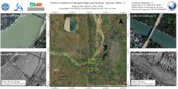
Pre/Post comparison of damaged bridges near Myanmar epicenter (30km)
2025-03-31
Utilizing ZY-1 high-resolution imagery (2-meter resolution) provided by the Land Satellite Remote Sensing Application Center, M...
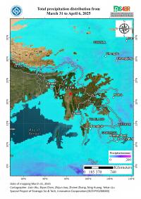
April 2025 Precipitation and Flood Risk Assessment in the Affected Region of the Myanmar Earthquake
2025-03-31
The Mw 7.9 earthquake that struck Myanmar's Sagaing Region on March 28, 2025, caused severe structural damage and increased the...
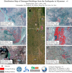
Distribution Map of Damaged Buildings from the Earthquake in Myanmar
2025-04-1
Leveraging GF-1B high-resolution satellite imagery (2-meter resolution) provided by the Land Satellite Remote Sensing Applicati...
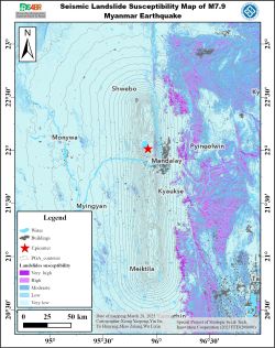
Integrated Multi-Source Data Assessment and Risk Warning of Coseismic Landslides Triggered by the 2025 Myanmar Mw7.9 Earthquake
2025-03-31
On March 28, 2025, a significant Mw7.9 earthquake struck near Mandalay in central Myanmar, posing risks of coseismic landslides...
Central South University team analyzed and revealed the damage situation of buildings in the Shigatse earthquake
2025-01-14
The China Earthquake Networks Center reported, a 6.8-magnitude earthquake occurred in Dingri County, Shigatse City, Xizang Auto...

Events
Earthquake
Landslide
Flood
Forest and grass fires
Volcano
Other disasters
Data List
|
About
|
Contact Us
|
How to use
ICP备案号:
© 2008 - 2022 IKCEST All rights reserved